 English (UK)
  Македонски
Floods are one of the most common and damaging natural disasters that seriously affect the environment, economy and safety of people, especially in parts of republic of North Macedonia where riverbeds are narrow and urbanization is unplanned.
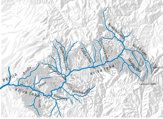
Floods are one of the most common and damaging natural disasters that seriously affect the environment, economy and safety of people, especially in parts of republic of North Macedonia where riverbeds are narrow and urbanization is unplanned. One such example is the Kriva Reka basin, which often overflows its banks during intense rains or sudden snowmelt, causing significant damage to the population, infrastructure and agricultural areas. The region around Kratovo and Kriva Palanka regularly faces floods due to the lack of sufficient protective infrastructure as well as poor coordination between local institutions that need to take timely preventive measures. The situation is worsening with climate change, which brings torrential rainfall with increased intensity in a short period of time, with river systems such as the Kriva Reka not having the capacity to drain water in a timely manner, which leads to flooding, erosion and destruction of the natural and human landscape. The need for detailed hydrological studies, regular maintenance of riverbeds and construction of protective channels and dams is urgent, and at the same time it is important to educate the local population about the risks and possible ways of protection, because only through cooperation and responsible planning can reduce damages and protect the lives and property of people in the Kriva Reka basin.
Urban flooding in the Kriva Reka basin is an increasingly serious problem, especially in the current conditions of intensified climate change and uncoordinated urban development. With the increase in sealed surfaces, such as paved streets, sidewalks and buildings, the natural ability of the soil to absorb rainwater is significantly reduced. In such conditions, even moderate rainfall can quickly lead to water retention, flooding of streets and overloading of drainage systems.
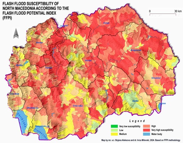
FFPI-based flash-flood susceptibility map calculated for every catchment in the country larger than 10 km sq.
As seen on the map, and according to the model used, the East and North-East part of North Macedonia (including Kriva Reka River basin) is most susceptible to flash flood events. The map is significant, considering the expected increasing frequency of heavy rain, storms and flash flood events.
In cities and towns along the Kriva Reka River, such as Kratovo, this phenomenon is particularly pronounced. Old and poorly maintained storm drains cannot cope with the increased water level during heavy rainfall, which leads to the overflow of water from the riverbed and the occurrence of urban flooding in low-lying parts of the city. These floods cause damage to roads, business buildings, basements and other infrastructure, as well as health and safety risks for residents.
Additionally, uncontrolled urbanization near the riverbed increases the exposure of people and buildings to flooding. The reduced green belt around the river and the lack of regulatory measures, such as protective walls and embankments, exacerbate the problem.
To reduce the risk of urban flooding, integrated urban spatial planning management, revitalization of drainage systems, preservation and expansion of green spaces, and introduction of nature-based solutions – such as permeable surfaces and rainwater retention systems – are needed. These measures should be part of a broader strategy for adapting cities along the Kriva Reka to climate change and more frequent extreme precipitation events.